Day 4, June 28, Fort St. John, BC to Ft. Nelson, BC
There were three possible routes on this leg of the trip. The
first route follows the Alaska highway through the mountains and is the
most scenic route, but there was a thin layer of lowish clouds that
might
descend into the valleys, so Plan B was to follow the railroad to the
east, in lower terrain. The third route is to follow the
airways--direct lines between radio navigation equipment--but this
required higher en route altitudes. We started out along
the highway and quickly realized we were going to run into the clouds,
so we headed for the railroad. The cloud heights were lower
than predicted and we ended up scud-running (flying below the clouds
and pretty close to the ground). I didn't feel locked in however,
because I knew we could 1) turn around, or 2) ascend into the
clouds. We were well east of the mountains and could intercept
the IFR (instrument flight rules) airway. Plus, the cloud
layer was fairly thin. Eventually the clouds thinned and
disappeared when we got to Ft. Nelson. We talked to other pilots
there who said they just punched through the clouds and flew on top,
which is against the rules. In retrospect, probably the best
thing to do would
have been to file IFR but I didn't have charts, and it turns out a lot
of these airports didn't either! Then we would have punched
through the thin layer of clouds to clear blue sky all the way to Ft.
Nelson. Next time I will be prepared to fly IFR. The only
picture I snapped was a blurry picture of what looked like a cell-phone
tower (not shown here). And here I thought we were in the
boonies.
At Ft. Nelson, we met up with Bob Taylor and his son from
Fairbanks. They informed us of the smoke from the forest fires
blocking our route all the way to Fairbanks. It's curious that we
didn't hear anything about this until we got up to Ft. Nelson. We
could make it to Lake Watson but the hotels in Ft. Nelson are
better, according to Bob, who has made the trip many times in his
Cessna 182. We called up Flight Service and confirmed that we
were stuck until the winds (currently from the northeast) changed
direction. Here's a satellite photo showing the
fires. The clouds at bright white, and the smoke has a slight
brownish hue.
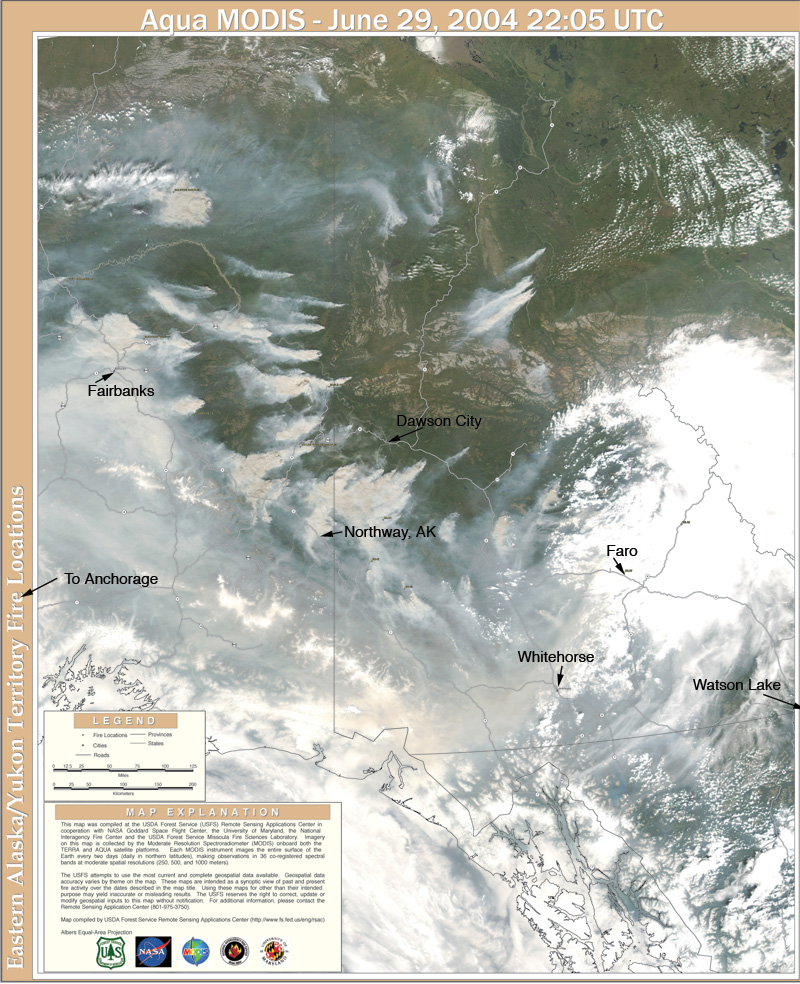
We wanted to get to Fairbanks or Anchorage following the highway
through Watson Lake, White Horse, and Northway (airport of
entry). All of these airports were closed, except
Anchorage, but that was beyond our fuel range. Fairbanks was <
1/4 mile visibility for a week, which is below even IFR minimum
requirements for landing. This is where I became jealous of
another airplane for the first time. Bob's Cessna182 has a
higher
cruise (about 170 mph) and longer range than my maule, not to mention
having an autopilot, so he could actually make it to Anchorage, and I
couldn't. But then he'd be stuck there because he still couldn't
get to Fairbanks. Notice that Dawson City is clear.
Ft. Nelson has a nice Super 8 Motel so we decided to stay the night and
decide what to do in the morning. The motel even had a high-speed
internet connection that was free.